
Executive Engineering Summary
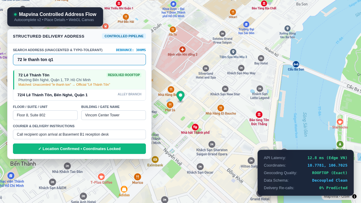
In emerging Southeast Asian e-commerce and logistics workflows, unconstrained free-text address inputs represent one of the primary drivers of last-mile delivery failure. When a customer enters an unaccented, abbreviated string such as "72 le thanh ton q1", an unmanaged system captures only raw characters—lacking geographic coordinates, standardized administrative boundaries, and delivery precision. Dispatchers are subsequently forced to make manual confirmation calls, while automated routing engines fail to assign drivers efficiently.
This architectural guide demonstrates how to engineer a high-precision, controlled address intake pipeline for web and mobile applications using Mapvina GL JS and REST APIs. We examine keystroke throttling with AbortController, dual-boundary administrative reconciliation (new_admin=true and include_old_admin=true), interactive map pin-drop fallbacks for complex alleyways (hẻm/ngõ), and decoupled enterprise database schemas designed to eliminate address ambiguity at the point of ingestion.
Address entry forms represent the first point of data quality control in any digital product involving physical delivery, on-site service scheduling, or territory management. In Vietnam, address capture is uniquely complex: users frequently omit tone marks, truncate administrative prefixes, rely on informal landmark descriptions, and alternate between historical and post-July 2025 reorganized administrative boundaries.
When an application provides only an unconstrained free-text field, software is forced to guess user intent retroactively after the session has ended. Conversely, forcing users through cascading dropdown menus (Province $\rightarrow$ District $\rightarrow$ Ward) introduces severe cognitive friction and fails when municipal boundaries merge.
The optimal software architecture is a controlled, multi-tier ingestion flow: provide rapid, typo-tolerant autocomplete during typing, resolve canonical coordinates and administrative components upon selection, offer an interactive map pin fallback for deep alleys, and cleanly decouple canonical spatial data from secondary unit delivery instructions.
Why a Single Free-Text Field Fails in Vietnam
A customer address is not merely a display string printed on an invoice. In a modern logistics or marketplace backend, that single record is consumed by multiple downstream systems:
Dynamic Freight Calculators: Require precise geographic coordinates (latitude, longitude) to compute road network distance and toll tariffs.
Warehouse & Hub Dispatching: Requires standardized district and ward entities to assign orders to regional fulfillment hubs.
Customer CRM & Master Data: Requires canonical administrative names to prevent duplicate records and ensure regulatory compliance.
Last-Mile Couriers: Require secondary sub-address attributes (floor, apartment number, building name, gate instructions).
An unconstrained text field introduces four compounding operational failures:
- Orthographic and Dialectical Permutations: The same physical parcel can be typed in dozens of formats: accented (72 Lê Thánh Tôn), unaccented (72 le thanh ton), abbreviated (72 LTT, Q.1), or colloquial (ngay ngã tư Pasteur).
- Unvalidated Intent vs. Confirmed Location: The database records what the user typed, but cannot verify whether the user intended Ho Chi Minh City, Vung Tau, or a provincial street with the same name.
- Cluttering Spatial Geometry with Unit Notes: Crucial secondary delivery notes—such as “Floor 8, Room 802, leave at front desk”—become inextricably entangled with the street line, causing geocoding parsers to fail.
- Administrative Restructuring Disconnect: Following the nationwide boundary reorganization effective July 1, 2025, customers frequently search using legacy ward and district names that have been formally consolidated. Without a dual-boundary engine, searches return zero results or resolve to obsolete spatial entities.
Architecture & Responsibilities: Mapvina API Ingestion Suite
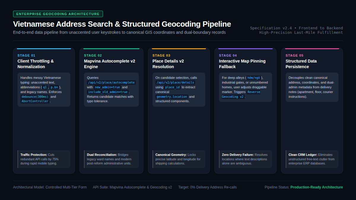
Building a production-grade address intake flow requires coordinating several distinct Mapvina API endpoints across the user interaction lifecycle:
1. Autocomplete v2 (`/api/v2/place/autocomplete/json`)
Engineered specifically for low-latency keystroke assistance. It accepts partial, unaccented, and abbreviated search strings (input), applying fuzzy matching and phonetic normalization. It returns a prioritized list of candidate predictions with place_id, description, structured_formatting, and matched_substrings. Crucially, passing new_admin=true and include_old_admin=true enables real-time resolution across legacy and reorganized Vietnamese boundaries.
2. Search v2 (`/api/v2/place/textsearch/json`)
Unlike Autocomplete—which optimizes for quick interactive suggestions—Search v2 is optimized for complete query strings, pasted clipboard text, or enterprise batch geocoding. It returns full geographic feature records, coordinate bounding boxes, and precision match flags (partial_match).
3. Place Details v2 (`/api/v2/place/details/json`)
Once a user selects a prediction from the Autocomplete dropdown, the client calls Place Details using the unique place_id. This endpoint resolves canonical geometry.location (latitude and longitude), viewports, standardized address_components (street number, route, ward, district, city), and legacy administrative entities.
4. Reverse Geocoding v2 (`/api/v2/geocode/reverse`)
Serves as the indispensable fallback for locations that lack official house numbers, newly constructed industrial parks, or deep alleyway residences. When a user drags a map pin to their exact doorway, Reverse Geocoding translates those coordinates (latlng) into the closest structured administrative hierarchy.
Engineering the Controlled Multi-Tier Address Form
A high-conversion, zero-error address entry form adheres to seven core engineering principles:
1. Unified Search Input over Cascading Dropdowns
Do not force users to choose Province $\rightarrow$ District $\rightarrow$ Ward before typing their street. Modern users think holistically: “Vincom Dong Khoi” or “72 le thanh ton”. A single responsive input allows natural keyword entry while Mapvina’s backend handles administrative entity extraction behind the scenes.
2. Controlled Keystroke Throttling & AbortController
Never dispatch an HTTP request on every keyup event. Implement a 300ms debounce window and initialize an AbortController. If a user continues typing before the prior request completes, abort the in-flight request immediately. This conserves API quota and prevents stale responses from overwriting newer predictions.
3. Informative Suggestion Rendering
Displaying only a raw string creates ambiguity when multiple streets share identical names across different districts. Leverage structured_formatting.main_text for the prominent location name, and structured_formatting.secondary_text for the ward, district, and province. When include_old_admin=true is enabled, render a secondary visual indicator showing the legacy boundary name so users confirm they have selected the correct location.
4. Atomic Selection & Dirty-State Invalidation
When a user clicks a suggestion, the application locks the resolved place_id and coordinates into component state. If the user subsequently edits or modifies the text box, the application must immediately invalidate the resolved coordinates and mark the form state as “unverified.” Otherwise, the system risks persisting coordinates that no longer match the visible text.
5. Decoupling Primary Street Address from Secondary Delivery Attributes
Never allow apartment numbers, floor codes, or courier instructions to be mixed into the geocodable search string. Provide dedicated secondary inputs for Floor / Unit / Suite, Building Name, and Delivery Notes. This guarantees that Mapvina queries only clean spatial entities while logistics teams receive exact door-level details.
6. Interactive Map Pin-Drop Fallback
Vietnam’s rapid urbanization has created extensive multi-branched alley networks (hẻm/ngõ), where numerical house sequencing can be non-linear. The form must provide an optional “Adjust Pin on Map” modal. The user can drag a vector map marker directly to their building entrance, triggering Reverse Geocoding v2 to capture exact rooftop coordinates.
Production JavaScript / TypeScript Implementation
The following complete service class encapsulates debouncing, request cancellation, prediction normalization, and place detail retrieval:
export interface AddressCandidate {
  placeId: string;
  primaryText: string;
  secondaryText: string;
  fullAddress: string;
  legacyAddress?: string;
}

export interface GeocodedAddress {
  placeId: string;
  formattedAddress: string;
  latitude: number;
  longitude: number;
  streetNumber?: string;
  route?: string;
  ward?: string;
  district?: string;
  city?: string;
  legacyAddress?: string;
}

export class MapvinaAddressEngine {
  private abortController: AbortController | null = null;
  private debounceTimer: number | null = null;

  constructor(
    private readonly apiKey: string,
    private readonly debounceDelayMs: number = 300
  ) {}

  /**
   * Dispatches debounced Autocomplete query with in-flight cancellation
   */
  public search(
    query: string,
    onSuccess: (candidates: AddressCandidate[]) => void,
    onError?: (error: Error) => void
  ): void {
    if (this.debounceTimer) {
      clearTimeout(this.debounceTimer);
    }

    if (!query || query.trim().length < 2) {
      onSuccess([]);
      return;
    }

    this.debounceTimer = window.setTimeout(async () => {
      try {
        if (this.abortController) {
          this.abortController.abort();
        }
        this.abortController = new AbortController();

        const params = new URLSearchParams({
          input: query.trim(),
          key: this.apiKey,
          size: '5',
          new_admin: 'true',
          include_old_admin: 'true'
        });

        const res = await fetch(
          `https://maps.mapvina.com/api/v2/place/autocomplete/json?${params}`,
          { signal: this.abortController.signal }
        );

        if (!res.ok) {
          throw new Error(`Autocomplete HTTP status: ${res.status}`);
        }

        const data = await res.json();
        if (data.status !== 'OK' && data.status !== 'ZERO_RESULTS') {
          throw new Error(data.error_message || `API error: ${data.status}`);
        }

        const results: AddressCandidate[] = (data.predictions || []).map((p: any) => ({
          placeId: p.place_id,
          primaryText: p.structured_formatting?.main_text || p.description,
          secondaryText: p.structured_formatting?.secondary_text || '',
          fullAddress: p.description,
          legacyAddress: p.old_formatted_address || ''
        }));

        onSuccess(results);
      } catch (err: any) {
        if (err.name === 'AbortError') return;
        if (onError) onError(err);
      }
    }, this.debounceDelayMs);
  }

  /**
   * Resolves detailed coordinates and components from selected candidate
   */
  public async resolvePlace(placeId: string): Promise<GeocodedAddress> {
    const params = new URLSearchParams({
      place_id: placeId,
      key: this.apiKey,
      new_admin: 'true',
      include_old_admin: 'true'
    });

    const res = await fetch(
      `https://maps.mapvina.com/api/v2/place/details/json?${params}`
    );
    const data = await res.json();

    if (data.status !== 'OK' || !data.result) {
      throw new Error(data.error_message || 'Unable to resolve place details');
    }

    const item = data.result;
    const loc = item.geometry?.location;

    // Parse structured administrative components
    const components: Record<string, string> = {};
    (item.address_components || []).forEach((c: any) => {
      if (c.types && c.types.length > 0) {
        components[c.types[0]] = c.long_name;
      }
    });

    return {
      placeId: item.place_id,
      formattedAddress: item.formatted_address || item.name,
      latitude: loc?.lat || 0,
      longitude: loc?.lng || 0,
      streetNumber: components['street_number'],
      route: components['route'],
      ward: components['sublocality_level_1'] || components['administrative_area_level_3'],
      district: components['administrative_area_level_2'],
      city: components['administrative_area_level_1'],
      legacyAddress: item.old_formatted_address || ''
    };
  }

  /**
   * Reverse geocodes coordinates when a user drags a map pin
   */
  public async reverseGeocode(lat: number, lng: number): Promise<GeocodedAddress> {
    const params = new URLSearchParams({
      latlng: `${lat},${lng}`,
      key: this.apiKey,
      new_admin: 'true',
      include_old_admin: 'true'
    });

    const res = await fetch(
      `https://maps.mapvina.com/api/v2/geocode/json?${params}`
    );
    const data = await res.json();

    if (data.status !== 'OK' || !data.results?.length) {
      throw new Error(data.error_message || 'Reverse geocoding failed');
    }

    const item = data.results[0];
    const loc = item.geometry?.location;

    return {
      placeId: item.place_id || 'pin_drop',
      formattedAddress: item.formatted_address,
      latitude: loc?.lat || lat,
      longitude: loc?.lng || lng,
      legacyAddress: item.old_formatted_address || ''
    };
  }
}
Enterprise Database Schema & Canonical Persistence
A sophisticated UI component provides little business value if backend systems persist only raw text. The following schema represents the production-grade data model recommended for enterprise order management, billing, and logistics ledgers:
{
  "address_id": "addr_982341",
  "customer_id": "cust_45102",
  "raw_input_text": "72 le thanh ton q1",
  "selection_method": "AUTOCOMPLETE_CONFIRMED",
  "verification_status": "ROOFTOP_VERIFIED",
  "canonical_address": {
    "formatted_string": "72 Lê Thánh Tôn, Phường Bến Nghé, Quận 1, TP. Hồ Chí Minh",
    "street_number": "72",
    "route": "Lê Thánh Tôn",
    "ward": "Phường Bến Nghé",
    "district": "Quận 1",
    "province_city": "TP. Hồ Chí Minh",
    "country_code": "VN"
  },
  "spatial_coordinates": {
    "latitude": 10.7781,
    "longitude": 106.7025,
    "precision_level": "ROOFTOP",
    "geohash": "w3gvd8x"
  },
  "administrative_metadata": {
    "admin_mode": "POST_JULY_2025_NEW",
    "legacy_formatted_address": "72 Lê Thánh Tôn, Phường Bến Nghé, Quận 1, TP. Hồ Chí Minh",
    "official_id": null
  },
  "secondary_delivery_details": {
    "building_name": "Vincom Center Tower",
    "unit_or_floor": "Floor 8, Suite 802",
    "courier_instructions": "Call recipient upon arrival at Basement B1 reception desk"
  },
  "audit_telemetry": {
    "provider": "MAPVINA",
    "api_version": "v2",
    "place_id": "mv_pid_089123",
    "captured_at": "2026-10-16T02:25:00Z"
  }
}
Data Architecture Warning: Note that
official_idis defined asnull. Mapvina documentation notes that official administrative identifiers are only assigned to territorial units (such as municipalities, wards, or communes). Standard street addresses and building parcel numbers do not carry official government administrative IDs. Applications should generate internal primary keys (address_id) and avoid assuming that every parcel carries a national administrative serial code.
Security, Key Hygiene & Traffic Governance
Because address search components reside primarily on public-facing browser and mobile interfaces, teams must enforce strict security controls:
- HTTP Referrer Domain Allowlisting: Mapvina API keys embedded in client bundles must be restricted in the Mapvina Management Portal to authorized production and staging domains (e.g.,
<em>.yourdomain.com/</em>). Any request originating from unauthorized hostnames will receive an immediateREQUEST_DENIEDstatus. - Never Expose Customer PII in Geocoding Payloads: Customer full names, phone numbers, order values, and private notes must never be appended to Mapvina API query strings. Query parameters must contain only pure spatial descriptors.
- Traffic Conservation: Implementing a 300ms debounce window and a minimum threshold of 2 characters reduces outbound Autocomplete API volume by upwards of 75%, shielding enterprises from unnecessary bill escalation during typing spikes.
Operational KPIs & Phased Implementation
To measure the business impact of transitioning from an unconstrained input to a controlled Mapvina address engine, track these key metrics:
Suggestion Resolution Rate: The percentage of users who select an official Autocomplete candidate versus falling back to manual entry (Target: $>88\%$).
Delivery Re-call Rate: The percentage of dispatched orders requiring courier phone calls to clarify address directions (Target: $<2\%$).
Coordinate Rooftop Precision: The proportion of saved customer records containing high-confidence geocoded coordinates (Target: $>95\%$).
Cart Abandonment Velocity: The median seconds elapsed between focusing on the address input and confirming the form (Target: $<12\text{ seconds}$).
Recommended 4-Week Rollout Plan:
Week 1 (Audit & Sample Ingestion): Collect 2,000 anonymized historical address records. Categorize by unaccented text, abbreviations, legacy administrative terms, and informal landmarks.
Week 2 (Frontend Component Prototyping): Implement MapvinaAddressEngine with debouncing, AbortController, and decoupled unit inputs. Test on low-end mobile devices under throttled 3G connections.
Week 3 (Controlled A/B Pilot): Route 20% of live checkout traffic through the new Mapvina controlled flow. Monitor API latency, candidate selection rate, and error logs.
Week 4 (Full Deployment & Ledger Migration): Expand to 100% of web and mobile intake. Backfill coordinates and dual-boundary tags into historical customer records.
Conclusion
An effective address search box is not merely a visual convenience; it is the fundamental quality gate for your enterprise spatial data. By moving away from unstructured text fields and implementing Mapvina’s controlled Autocomplete, Place Details, and Reverse Geocoding pipeline, engineering teams can eliminate shipping re-calls, insulate systems from administrative boundary shifts, and build a scalable foundation for high-precision logistics across Vietnam.
References & Official Documentation
- [1] Mapvina Autocomplete API v2 Specification: https://docs.mapvina.com/api-integration/autocomplete/v2
- [2] Choosing Between Search and Autocomplete Guide: https://docs.mapvina.com/guides/choosing-search-and-autocomplete-guide
- [3] Mapvina Place Details API v2 Specification: https://docs.mapvina.com/api-integration/place-detail/v2
- [4] Mapvina Search API v2 Specification: https://docs.mapvina.com/api-integration/search/v2
- [5] Mapvina Reverse Geocoding API v2 Specification: https://docs.mapvina.com/api-integration/reverse-geocoding/v2
Trích dẫn & Nguồn gốc nội dung
Nội dung chuyên môn, cấu trúc giải pháp và thông số tham chiếu trong bài viết này được đối soát trực tiếp từ hệ thống dịch vụ của trang gốc: MapVina.com ↗.
Tìm hiểu giải pháp Maps API của MapVina
Nền tảng bản đồ số và dữ liệu địa chỉ tối ưu cho thị trường Việt Nam.
Khám phá MapVina ↗